Amusing Raven
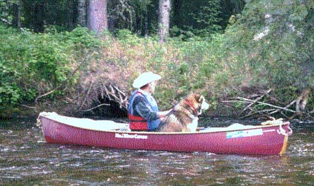
Keno and I in my Mad River Courier on the Chatanika in 1998
This is a story about my trip with my Malamute, Keno, down the
Background - Spiritual
The Koyukon of central
So Raven is seen as a sophisticated Creator who invents entropy and mosquitoes (and possibly Snackwells) at a single stroke. The Judeo-Christian story is silent on all three of these important inventions. We lost Paradise not because of Original Sin, but because we weren't amusing enough.
So, while an enterprise such as making your way upriver through a swarm of mosquitoes might be Hell on Earth, it is very entertaining to Raven.
Background - Historical
In 1875, Arthur Harper and Frederick Hart camped near the Han Indian village of Fetutlin on the Yukon near the mouth of the river whose Indian name Tappan Adney rendered as "Zit-zen-duk" (meaning The River of the Leaves because its waters acquire a deep reddish brown Lapsang Souchong tea color from the muskeg through which so much of its water has to percolate.)
The year before, Jack McQuesten had established a trading post at Fort Reliance, and that became the reference point for prospectors and explorers in the upper Yukon. Because the mouth of the Zitzenduk was estimated to be forty river miles below Fort Reliance, the white man named the river, its drainage, and the mining district that grew there the Fortymile.
Harper and Hart panned the gravel on the bar at the mouth of their Fortymile and found traces of gold. They wanted to explore upriver, but the Indians warned them that an impenetrable canyon lay about ten miles upstream. Harper and Hart decided that there were many easier prospects for them to explore before taking on the canyon.
It was a pretty good story, because it stunted exploration of the Fortymile, and it wasn't until eleven years later that gold was found in workable concentrations on its upper reaches. Even then it was a difficult river to work. Here's how Mike Gates describes it in Gold at Fortymile Creek:
[the river's] main characteristics are its fast-flowing current and the canyon at its lower end. Though not comparable to the Grand Canyon, the constriction of the river between the Canadian hills was not to be underestimated, particularly during high water. At least a half a dozen men lost their lives here in 1887.
Tracking upstream through the canyon was brutal, cold, wet work, but it was the downstream passage that took lives.
Background - Modern
So, in my
On Friday July 9, I could have turned right out of the Yukon River Campground to return to Fairbanks, and no one would have known of my secret plan. But I turned left, took the ferry to Dawson, and handed the outfitter my Mastercard. "I plan to be at Forty Mile next Tuesday. Can you pick me up?" "Sure," he said. The die was cast.
I fiddled with the canoe interminably at the put-in, rigging floatation and new seats. When I could put it off no longer, I dragged the boat to the water's edge, broke a dog biscuit in two, and lured Keno into his place in the boat. He's pretty tricky, so he can't be actually given the biscuit until we have shoved clear of land - not that far for a Malamute.
I kept a log of the trip, written partly as a letter to my ladyfriend, Marilyn, partly to myself, and partly to Dear Diary. I could try to edit it to make it less boring, but that might damage it. Here goes. Just skip the boring parts and the technical detail.
Friday July 9, 1999
4:30pm - leave Dawson. Hot, smoky, high clouds.
~5:00pm - Moosehide. [Moosehide is the Indian village on the right just below Dawson, named, it is said, because it lies just beyond the hill that forms the backdrop for Dawson, a hill that is dominated by a scar left by a rockslide (not related to mining) which resembles a huge skin stretched out to dry.]
5:40pm - Fort Reliance. [note to cheechakos: Arthur Harper established a
trading post at Fort Reliance on the Yukon River, just about six miles below
the present site of Dawson (which, of course, didn't exist as Dawson until
1896), and it was from this origin that the locations of other Yukon features
were referenced.
5:50pm - break below Fort Reliance. Check GPS: 6.21 miles from Dawson.
7:00pm - Met the Yukon Queen II coming back from Eagle. [The Yukon Queen is a touring catamaran that makes a daily round trip excursion from Dawson down the Yukon to Eagle in Alaska each day. It leaves a huge wake.] Managed to get a gravel bar between me and her.

We're in the middle of the burn. Smoke still rising with a slight breeze. The
valley ahead is starting to fill with smoke. Heading into the sun for the next
few miles w/ a tail wind. Something new.
8:50 - break.
Forty Mile 24.0 mi
139deg 48min
Probably Fresno Creek. Mostly through the fire. Beginning to cool. If an
inversion sets in, the valley will fill up with smoke. On to Woodchopper Creek
~ 7 raven miles. Maybe 2 hours?
11:00 pm - Woodchopper Creek. Stop for the night.
Dawson 24.8 mi
Forty Mile 17.0 mi
64deg 10min 10.9sec
140 deg 00min 20.4sec
I had set a GOTO on the GPS using map coordinates and missed it by only a
quarter of a mile. According to the outfitter, Woodchopper was occupied by a
fisherman named McPhee [no relation, evidently]. He built a two-story frame and
plywood cabin on a bluff overlooking the river. He died in an automobile
accident not too long ago, and the place remains as he left it - less some
window vandalism and the dead owl on the floor.
I cooked and slept on the beach. Note to self for future puzzlement: upstream beach of Woodchopper is rocky, downstream is quicksand. Ramen for dinner with tuna. Burned out the can and stowed the food in the drybag on a boulder on the beach. No sign of ANYTHING here. No scat, no tracks. Just ravens quarreling with seagulls.
Saturday, July 10, 1999
Kept rolling over and going back to sleep. Smoke has the visibility down to a mile or less. Wait for the sun to mix up the atmosphere a bit. Finally got up when the Yukon Queen II came by.
11:30 am - sun, breeze, clearing, but fires down to the water ahead. Finally
got going about
1:00 pm - hot sun. gusting tail wind. Fires at the waterline. Spruces look
as if they were DESIGNED to burn. They don't 'burn' as much as 'go off.'
Suddenly, out of a smoldering thicket, one will go off like a F1 rocket engine
on a test stand.
The smoke plumes turn into puffy white cumulus when they reach an altitude
where the temperature matches their dew point. On some of the plumes, that
transition is a sharply defined horizontal plane. The miners at Jack Wade say
that these turn into afternoon rain clouds and drop dirty, ashy showers.
Cassiar Creek
64deg 19min 45.7 sec
140deg 09 min 57.6sec
Dawson 28,9 mi
Forty Mile 12.4 mi
Woodchopper 4.98 mi
Beautiful-looking log cabin and camp here. Didn't snoop around.
2:15 pm - Floating ahead of a tail breeze. I've given up trying to trim the
boat for wind. It just wants to be broadside to it. Period.
About 10 miles above Forty Mile. Pretty good visibility - a couple of miles
anyway. Not good enough to get out the binoculars, though. Warm sun, occasional
fire clouds. (I can call them that, now that I've witnessed their formation.)
We're on that long curving section that begins about 145deg 15min [for those of
you following along on their maps] A couple of gulches on the right hand side
for lunch prospects. This is a beautiful section of the river. Castellated
cliffs - some the color of
2:30 pm - lunch break on the right just below a keyhole notch on the left.
Forty Mile - 7.7mi
64deg 21min 37.9sec
140deg 18min 12.3sec
Dog walked around a bit sniffing. There's so little here to interest a dog that
he stepped back into the canoe and curled up.
Gulches - there's a characteristic form here, especially on the left hand side. Many of the smaller creek valleys are shrouded by the cliffs that form the river course. There'll just be a narrow notch for the creek valley to drain, but the broad valley [some might be hundreds of square kilometers in extent] itself is visible from the river only through the notch as you float by. An odd and unexpected little drama.
3:30 pm - Long lunch break. I'm not anxious for this part of the trip to end. There may be people at Forty Mile that I'll have to be polite to.
4:00 pm - Coasting. Note to self: Bring along a geologist next trip. Cliffs below lunch have everything: stratification, uplift, metamorphosis, intrusion.
Ugly dark brown smoke cloud lurking just to the north beyond the cliffs. Other fire clouds have turned nimbus, but they've delivered no rain yet. Intermittent hot sun.
4:20 pm - Coasting to the end of the cliff wall on the lhs. Huge ugly brown/gray plume arcing over the river behind us. ~5 miles to go. Must be about time to start drifting to the left side.
5:30 pm - Forced to the shore about a half mile above Forty Mile by the Yukon Queen II. Her waves break on the beach with some force, so you want to stand off far enough to avoid the break but close enough to swim.
The smoke plumes are beginning to crash, and the valley is beginning to fill with smoke. Light rain falling. Now that I've watched the whole process of fire/cloudtop/rain cloud/rain, I'm an expert.
Headache. Hope that it's not from the Top Ramen last night. If it was the Ramen, then it's going to be a long trip, because that's what's for dinner until Tuesday night. Maybe I can trade with Keno.
7:00 pm - Slept for about 90 minutes. Tired. Paddle down to Forty Mile and into a deadend in the bar at the mouth. I walked through the site past Sebastian and Shelley's place, up the south shore of the Fortymile. A large raft was beaching on the far shore.
7:30 pm - Dear Diary: What follows is a truly preposterous Alaskan story: Not one raft, but four fully loaded rafts full of 11 people from Channel 11 in Anchorage were there, filming for a 1 hour special on the river. Remember, Dear Diary, how reluctant I was to discuss this trip with anyone for the following reasons:
1) They would think that I was crazy,
2) If I chickened out, I would have to explain, and
3) I really don't care what anyone else thought of it.
Well, Channel 11 threatens to make my trip into a featurette, and they took footage of my arrival, an interview, and my departure, into the smoke, poling up the Fortymile. One of their party was a state historian named Rolfe Buzzell.
Sunday July 11, 1999
11:00 am - Here I had planned a solitary departure, but I end up co-opted by big media for lagostino linguine, filet mignon, eggs over easy, and real hash browns. The three cups of coffee in the morning made my headache vanish. I guess that means that I'm back in trouble tomorrow when I go back to tea.
After I let the dog loose in the morning, he tested the bear-proofness of the camp. It failed. He broke into the bag of powdered potatoes and ate half of it. After everyone got up, Rolfe and I convened a miner's meeting, convicted him, and banished him up river.
I left at noon, bowing to the requirements of showbiz and poled into the distance. I hope that they got some snippets where I managed to keep the thing going straight.
Interim conclusions: Nothing works particularly well.
1. Paddling is a loser because a.) slow water is too shallow and deep too fast, and b.) you can't stop to rest without losing ground.
2. Lining [pulling the boat upriver with a line, walking on the shore]
3. Tracking [pulling the boat upriver with a line, walking in the river]
4. Poling. Probably the best once technique and terrain are mastered. On the lower river, there are long stretches of gravel beaches on the insides of bends. You can make time here. Swift water is tricky, and a little slip could dump us or break the pole. Practice, practice, practice.
2:45 pm - Leave. Less than 1 mile to the
4pm - 3.25 raven miles above Forty Mile. A relentless 1 mph. Some lining above the bridge. Mostly poling. In this section of the river, anyway, it was easy to change sides. [The procedure in an orderly section of the river is as follows: you pole up the slack water in the inside of bends along the gravel bar that tends to form there. Then, when the river bends the other way, and you face the swift water and the cutbank, you ferry across to the other side and proceed with the poling.] I let the dog run along the banks then lure him into the boat to cross over. Lunch. Tailwind makes it difficult to keep the boat pointed upriver.
5pm. - Get going again.
7:30 pm - Stop for the night. I'm figuring that I'm a lot more tired than I feel. I generated a lot of adrenaline not losing everything that I'd gained in that last slot. I had tracked/poled up the river-right side at the island, and that turned out to be the way to do it. But at the top of the island, I tried to pole-ferry over to river-left too soon, and I almost got swept down the main channel. I crashed into a dirt/willow bank and clawed my way back out. Whew. Soo... next time, go farther up river-right before ferrying over.
Not a very picturesque camp site, but decent sites will probably get rarer as we go up. Broad gravel bar on river-left, ragged, hoary cliffs on the opposite side. The hills seem to get steeper as they bend right going upstream.
There's no apparent animal sign. No tracks, no scat. Fine with me.
We're at UTM 07 W 051 6591 / 713 8097, 5.52 raven miles to Forty Mile. I'm feeling kinda closed in, but there's blue sky over the downstream valley and fire clouds everywhere else.
Monday July 12, 1999
10:10am - Woke up at about 5a to put the rain fly on the tent. Finally got
up at 9. Overcast, light rain, not enough to get anything wet. Chill headwind.
It's going to be a different kind of day today. Maybe that's why I'm writing in
the book instead of poling... Note to self: Don't camp for the night at the end
of a long easy stretch. You can use it better the next day to warm up on.
Instead, I'm looking at a tricky section up ahead. I'm feeling not too bad
after yesterday, all things considered. On with it at
11:30am - Long lining section. Lining holding the boat in the channel with the pole worked ok. I was able to stay dry, slinging the boat around rocks with the pole, then stepping upstream to draw on the line. UTM 07 W 05 15738 / 713 7725, 6.04 raven miles to Forty Mile.
This method of lining is medium strenuous, but you always (more or less) have control of the boat, and you can rest whenever you want to. The same cannot be said about poling in tricky moving water.
The canyon here is half formed. The hills on river-right are more or less continuous. On the map, it looks like the hills on the other side close in in the next mile or so. Get going again at about 12:30 after tea and a raspberry bar and think.
1:30pm - Lunch break.
Well, we're in the canyon fer sure now. The water is still polable, but barely. None of the techniques developed so far are going to work through here. It's deep near both shores, the bottom is boulders that grab the pole and try to snap it. Disconcerting. UTM 07 W 05 14106 / 71 38168, 6.66 raven miles to Forty Mile.
It's not at all clear which side to go on here, but if I'm going to portage the [canyon] rapids, I want to be on river-right [my left]. It's going to be too hard going for the dog on shore, so I'll have to keep him quiet and happy in the boat. I've had to use bribes the last two times. When I run out of biscuits, I'll have to turn back. More cheer: 21.4 miles to the Fortymile Bridge.
I'm on river-right after an 'obvious' crossover. I guess that I'll try to stay here. My poling technique in this deep water is improving, and I can make way in these bouldered sections. Yet another difference between down and up: going up, the rocks are your friends to be approached, cuddled up to and exploited mercilessly.
Still lunch break. Sun. Blue skies. I'm stopped on the south shore so the hills mostly shade the spot. Other side of the river is a precipitous rubble pile. I had only one Wasa cracker left over from my contribution Saturday night. I might get hungry tomorrow, so I'd better save the trail mix til then.
This is a wonderful section of the river. I wonder why there isn't more traffic. Except for the Yukon Queen and Channel 11, I haven't seen a soul below Reliance.
I've slipped into an hour-on/hour off schedule, and it seems to work ok. It might sound a little casual, but the exertion during the hour-on is comparable to my 6 miles in the woods per hour running pace, and I never do 5 or 6 sets of those in a day. Much less days at a time. Pole-lining is also fairly strenuous, plus it works the back muscles quite a bit. Today, I haven't had a terror-poling episode yet. I'm sure that they peg the heart rate meter.
2:20 pm. - Pushing off for the hard part.
3:54 pm. - Through the canyon! Or at least it looks like it. Or at least, I don't want to do any more. UTM 07 W 05 13350/71 38327. Hmmm. Doesn't look that close to Bruin Creek. There must be more.
The lower section of the canyon can be paddled on river-right [at the low water levels I encountered]. The water is deep, and there are eddies along the fairly steep wall to hide in and rest. From them, you can get a run at the fast water and duck into the next eddy up. At higher water levels [if the eddies go away], this would be a VERY difficult section. It's too deep to pole or track, and there's no room at the sides to line or portage.
The paddle/line/track [no poling] up the canyon rapids was just barely doable. It would have been easier on the boat to have portaged it. It's an easy paddle-ferry across to river-left at the top of the rapids. Looks like a long pole up that side. Fairly shallow, judging from the ripples. As bad as this is, the hour-off is grand, with sun and blue skies. But if this were hypothermia weather, I'd certainly be wondering what I was doing here.
My thumbs have turned to raw meat. At least the left one wears through every paddling trip, but this time, it's both. You'd think that I could grow calluses there, but evidently not.
Equipment: So far the Xtratuf boots have been the ticket. I haven't filled them once. I've purged all cotton from my kit, and that seems to work. The nylon pants dry quickly enough. I came equipped for hypothermia conditions with layers of fleece and Gore-Tex, but, so far, the trip could have been made with shorts and Tevas. The single biggest contributor to standard of living in the boat is the bailing sponge. I should have removed the bow seat so I could lower the center of gravity of my dry bag when I'm trimmed for poling. Shove off at 5p.
6:09pm - Break after semi-enjoyable pole. Had to line some of the riffles (a couple of sets) and finally filled the Xtratufs in a panic abandonment of poling mode.
Heard thunder a bit ago. This is far enough to declare complete success
8.12 raven miles to Forty Mile.
05 11225
71 38036
19.6 miles to the Fortymile Bridge
Looks like about 7 miles to the international border. Might have been able to
make it in another day. Getting ready to shove off at
8.39 raven miles to Forty Mile,
19.4 miles to the
07 W 05 10909
71 37505
on the banks of what must be Bruin Creek. There's a nice-looking bar stretching
upriver, so maybe we'll walk up after I get camp set up and have dinner. Just
one more km to get out of this square.
The absolute first thing that has to happen during camp setup is feed the dog. I gave him all but one ration for tomorrow, he inhaled it, dug a huge hole, and curled up in it immediately.
Looks like smoke over the top of the hill to the north. Smells like it too.
8:30pm - after dinner of Cajun Top Ramen and canned tuna. mmm. Thing to decide now is whether I hike upriver to look around the next bend. Pluses: I could get another click on the GPS. Minuses: I'd have to put on my wet boots again to cross Bruin Creek.
Oh, wash the bowl, quit whining, and get going.
9:03pm - Well, here's a bedrock point where the river turns left at 8.91
miles from Forty Mile.
05 10269
70 37231
It would have been an easy pole to here and for some distance beyond, but some
tricky crossovers would have to happen.
Head for the tent. Rain clouds moving in and wind picking up.
9:30pm - J-u-s-t made it. Overturned the boat and climbed into the tent. Fairly decent rain - hardest we've had for a long time. Will make tomorrow fun.
Tuesday July 13, 1999
7:40 am - Rained for about two hours last night - enough to douse the fires and soak the tent floor. Got up at 6 to a misty valley with clouds hanging onto the hills. It's warm, but overcast. It doesn't look likely that we'll get any sun today. I suppose that I'll get really wet today so, dear diary, I'm packing you and everything else in the boundary pack, lashing it in tightly, and leaving the only things loose in the boat the bailing bucket, the sponge, the dog, and me.
10:00am - Well, I lied about not writing anything today, but we're through the canyon and a couple of the worst riffles below it.
We stopped at about 9am above the canyon, blew up the airbags, and thought about things.
We took in a huge amount of water in the canyon. First a little in the first couple of haystacks, then a lot on the last hole. [One of the supposed advantages of poling is that you get to scout on the way up, so that down is easier. In this case, the biggest problem was a hole at the bottom of the last drop. A trivial exercise for a kayaker, but a serious thing for an open boater out there in the Great Alone. I thought that I would be able to skirt it, nosing through a curl coming off a big rock on the right. Fine plan, I thought. Trouble was that the dog (who weighs maybe 85 pounds, and who hates to get wet) went nonlinear as soon as the water started coming in the first haystacks, and by the time we got to the drop, it was all I could do to keep the boat straight, and we hit the hole head on.]
It's going to be very difficult getting him back into the boat.
After two hours, we're 6.5 miles from Forty Mile at 05 14973, 71 37441 a little below where we had lunch yesterday.
I have eight hours to get to the Forty Mile takeout, and that has to include poling (or portaging) back up the Yukon to the roadhead. Time to pack up and begin cajoling the dog into getting back into the boat. Below the canyon, he would start crying and howling whenever we approached whitewater. I'm sure the worst is over, but there are still some navigation puzzles to be worked out. Happy, happy guy :)
Backtracking to fill in the day:
It turns out that there were lots of things to get through. The section at the island looks quite a bit different going down than it does going up. Up, on river right, it was a long, long slog of difficult lining and tracking. But down, the river presents itself as a strange distortion. Behind the island, the world seems to drop away. There must be a huge vertical drop through that section that hides between the coarse contour lines on my map. As you approach, no routes are visible. They're shielded by the terrain. The local horizon had 1.) the little chute on the right that I came up (and I knew that I didn't want to go down it), 2.) the island, and 3.) the main channel on the left. The horizon on the left channel began at the island bar then dropped off left in an alarming arc.
My rule is to follow the water, but this was a counterexample. As I followed the channel it ran close to the willow bank where I had rescued myself from the poling blunder Sunday afternoon. The willow bank abruptly changes to a rock wall with a sharp lurch to the right and a pronounced downward acceleration. The water banked up against it and I suppose that the boat did too. Then the climax - a boulder against the wall that sent a curl that churned out into the rest of the channel. [It was one of those moments when things turn to slow motion, and when I reconstruct it in my mind I reach up to the nose and execute a heroic cross draw, but I probably really just paddled like hell.] I avoided the rock, but just barely. There was a long runout of alternating sluices and haystacks. The dog climbed onto the stern floatation, evidently prepared to abandon ship. I couldn't blame him.
It's only now sinking in that if I hadn't made that save Sunday afternoon, I would have been swept into that chute, trying to sit down, stow the pole, get the paddle, and read the river. If I hadn't made that move, the trip would have turned out much differently.
A very odd and scary part of the river. After that, the dog whimpered most of the way down to Forty Mile.
The bottom few miles are a wonderful paddle, with the valley opening and softening until the far bank of the Yukon appears through a square slot.
When I got to Forty Mile, there was a riverboat tied up on the Fortymile side. I hoped that it was Sebastian, and I hoped that I would be able to sweet-talk him into giving me a ride up to the roadhead - another mile or so back up the Yukon. Another mile for a now-seasoned poler? By now, I had no stomach for it if I could avoid it.
I walked up to the cabin, and Sebastian was there. He had come down from Dawson to work on his fishing boat, but he was waiting for the weather to clear. I tied the dog up outside and took Sebastian's offer of a chair and a cup of coffee. We talked of many things. Poling, lining, living in the Yukon, Forty Mile, Bill McPhee...
The dog slipped his collar and walked in uninvited. He sniffed around some of the foodstuffs, and, after getting yelled at a few times, collapsed on the floor and a large mud puddle formed around him. Sebastian just shook his head. "Typical Malamute," he said. He and Shelley now have sixteen dogs that they mush with in the winter. They want to add two more so that they can make up two or three respectable teams. Except for the Quest, they are the only people mushing on this section of the Yukon. Odd.
In a week or two when the king salmon start arriving, he'll set out his fishwheel for them. He sells them commercially, and takes the chum salmon, which run later, for his dogs.
Eventually the weather cleared, and a little blue appeared, then the sun. We trooped down to the landing and loaded my boat crossways on his. We went quite a way out into the Yukon to clear the gravel bar that forms at the confluence and headed upriver at an unaccustomed speed. As part of my justification (rationalization?) for my trip, I had advanced the idea that for us to understand the impact of technology, we ought to have a clear understanding of what it means to do without. We yammer constantly about the cost of petroleum development, for instance, but commonly underestimate its benefits. We covered the mile in less time than it takes to write about it, and it would have taken me an hour to pole or line the distance, to say nothing of the harrowing negotiation of the bar.
Sebastian's project for the day was to screw battens onto his 'real' fishing riverboat to arrest some cracks that had appeared in the outer shell. Sebastian said that he couldn't have done it without another pair of hands. Maybe he was just being kind.
By then the sun was hot, so I spread out the contents of my dry bag to dry.
About this time, a couple from Toronto arrived after a two-day paddle down from Dawson. They said that there was supposed to be some abandoned village around here somewhere. They walked down the beach to investigate.
The van appeared early; we loaded up and we were gone. Keno seemed very happy to climb into it.
A couple of things led me to decide to get a room in Dawson for the night:
- the food store had closed,
- the campground had just reopened following an unprovoked black bear attack Friday, and Yukon Parks was recommending that people not sleep in their tents, and
- I needed an emergency shower.
I got a cabin at Klondike Kate's, had arctic char with double potatoes at the restaurant, went to the Downtown Hotel to call the Musick's to tell them that I had lived, bought a Partagas Habana and went to smoke it on the levee watching sunset on the river.
One of my better days.
Odd transition from five days where the most important things to keep track of were my knife and my lighter to a life where my wallet and car keys take those positions.
Wednesday 14 July, 1999
9:20am - Klondike Kate's for breakfast. A far cry from yesterday at this time. I was too wired last night to sleep, so I watched tv. First time since I left home six weeks ago that I've watched it not standing up. I like life a lot without it.
5:30pm - There's a spur off the Sixtymile Road near Swede Dome (It was common in gold rush times to name bad ground 'Swede Creek' or such, because Swedes were the only ones dumb enough to work it) that drops down into the headwaters of Bruin Creek. It's supposed to be a winter road that stays open when the higher more exposed alignment can't be kept open. Anyway, it's a magical little stretch of road, steep, steep walls and fireweed in blooms so dense that it looks like an English garden path. From one bend you can see down the Bruin Creek drainage as the mountains fold left-right-left-right to its confluence with the Fortymile where I was camped yesterday morning. From here, that's about 20 miles away.
On the topo map, the drainage of Bruin Creek covers a couple of the 100-square-kilometer squares, but at the Fortymile in July, it's just a little stream that you can wade across without getting your calves wet.
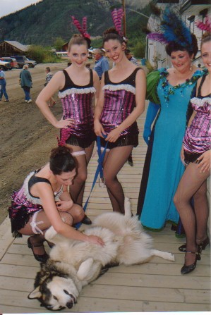
Keno relaxing with the ladies from Diamond Tooth Gertie's in Dawson
Even More Boring Details
Canoe - Mad River ABS Explorer with 30" floatation bags front and rear, Voyageur center seat kit with removable carry thwart.
Paddle - Cricket. The best in the world.
Pole - 12 foot, Home Depot closet rod.
Kit - tent, sleeping bag, mountain stove and cooking utensils.
Navigation - Garmin III GPS,
Copyright, Fred Klingener 2001, 2002
May be reproduced with copyright notice for personal use